Our happy customers
the best reward!
Thank you
Forest Map Objections
Submission and support of Forest Map Objections. Compilation and submission of the file for objections on posted Forest Maps, with documented technical report, autopsy of the current situation, photo interpretation and legal support from our external partner lawyer.
The company undertakes to complete all the work from the evaluation of the characterizations of the area on the D.X. and the structuring of the optimal approach for the submission of an objection up to the electronic submission and the submission of the physical file to the respective SYADX and the representation to the EPE.A.
About Forest Maps
The forest maps are the institutionalized (n.2664 / 1998 – Government Gazette 275 / Α / 3-12-1998) recording of the boundaries of the areas, which are subject to the protective provisions of the forest legislation.
Forest maps are compiled by demarcating and recording forests and forest areas during the process of photo interpretation of historical and recent aerial photographs and are displayed in the form of polygons on orthophoto map backgrounds. These backgrounds show the forest areas of two periods, an older period usually based on aerial photographs of 1945 or 1960 and a recent period based on the interpretation of the most recent aerial photographs of 2007-2009 or 2015.
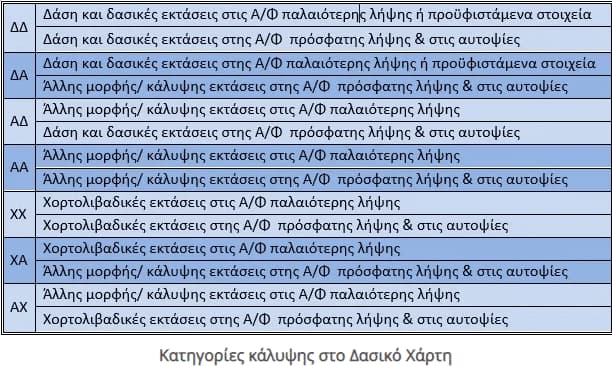
On the Forest map the descriptions that appear are:
The drafting of forest maps has as its formal purpose the environmental protection of forest and grassland areas, but in essence they are the tool of the State for the securing of Public property. The forest or grassland character of an area automatically raises ownership rights in favor of the Greek State as according to the law they are a stronger presumption than the ownership titles that the individual may possess. For this reason it is necessary to inform the citizen whether the areas he has fall under or not, depending on the nature attributed to them in the forest maps, the provisions of forest legislation and what restrictions this entails in terms of ownership or use. Also of great importance is the date to which the titles of ownership of a property are reduced as it affects accordingly both the possibilities of exercising prefecture on it and the actions that the individual needs to take when submitting the objection.
The posting of the Forest Charter is its first publication to the general public in order to inform the citizens about the nature of their areas, so that it can be judged and possibly corrected, after objection from any interested party. It is the only opportunity for any natural or legal person with a legal interest to defend the rights of the land that belongs to him and to prove with scientific criteria that the area he owned and still owns is not and was not forest, if this is the case. The means provided by the legislation is to object. For the areas of the Forest Charter for which no objection will be objected, a visa and ratification will be made immediately.
Who can Object - Necessary supporting documents for submitting objections
Objections can be submitted by natural and legal persons under public and private law, as well as the Greek State and the relevant Local Authorities. first and second degree, if they invoke for the establishment of their legal interest real estate or contractual rights in the forest, grassland and rocky or stony areas included in the forest map posted.
Objections especially against the failure to include in the forest map a certain forest character or grassland or rocky or stony area, can be submitted by any natural or legal person and, in particular, the Local Authorities. first and second degree administrative boundaries to which the area falls, environmental organizations and other non-profit legal entities, the purposes of which include the protection of the natural environment.
The necessary data / documents that are submitted in printed form to the competent SYADX (Support Point for the Posting of the Forest Map) and follow each submitted objection are the following:
a) A simple photocopy of identity card or passport,
b) The documents you rely on to prove the legal interest (in the form of simple photocopies),
c) Any evidence that you consider to prove or substantiate your claims, for the forest / grassland or non-forest nature of the area (administrative acts, certificates of competent services, irrevocable court decisions, building permit, photo interpretations, technical reports, etc.), which unquestionably,
d) Signed copy of your objection form,
(e) A copy of the proof of objection, and
f) Photocopy of the document certifying the payment of the corresponding special fee
Actions depending on the characterization of the area in the forest maps
The actions to be taken by the person concerned depend on the characterization of its extent on the posted forest maps. So if your area has any characterization except AA and PA, ie. ΔΔ, ΑΔ, ΧΧ, ΑΧ, you can:
- Apply free of charge for inclusion in an obvious (obvious) error of the forest map
If you think that there is an obvious error in the map, such as the designation as a forest that has always been agricultural due to an indisputable error in the interpretation, then you can:
i. To submit a free application for a manifest error through the special application that exists on the internet on the website of “Hellenic Land Registry SA”, www.ktimatologio.gr and specifically here.
ii. Submit a manifest error free of charge directly to the Directorate of Forests to which the area for which the application is submitted falls.
Note: submitting an application to join a manifest error category requires acceptance by the Forest Department and does not replace objection.
- Object to the nature of the area
i. The objection concerns only the nature of the area (not the property) and is submitted by anyone who has a legal interest.
ii. The objection is submitted through the application of “Hellenic Land Registry SA” on the website www.ktimatologio.gr and specifically here.
iii. The objection is submitted following the payment of a special fee determined by JM 151585/323 / 3.2.2017 (Government Gazette BD 347 / 08.02.2017) as amended by 155973/999 / 26.04.2017 (B ‘1491) and completed by 160525 /2210/20.09.2017 (Β ‘3327).
iv. In exceptional cases objections are submitted free of charge (for example parcels from distribution which appear as DA or ATHEX on the map).
- Use of both of the above
You have the option of simultaneously objecting and requesting a manifest error. In this case:
i. An obvious error request will be considered first.
ii. If the obvious error is rejected, the objection will be examined by the EPEA (Objection Examination Committees).
If your area is marked on forest maps as “AA” the “PA” you do not need to take any further action
Electronic submission of objections to the content of the posted forest maps
The submission of objections is possible only electronically, on the special website for posting forest maps and submitting objections, on the website of N.P.D.D. “Hellenic Land Registry”:
https://www.ktimanet.gr/CitizenWebApp/Entrance_Page.aspx
by filling out a relevant electronic form, using an online application.
- In order to file an objection, it is mandatory to complete the geographical coordinates of the vertices of the polygon / plot whose area is disputed in nature and shape, as well as its area.
- Also, for the submission of an objection, a special fee must be paid, the amount of which is calculated based on the area of the area that concerns it, as determined by JM 151585/323 / 3.2.2017 (Government Gazette BD 347 / 08.02.2017) as amended and in force.
Our company has the appropriate logistical infrastructure as well as the specialized scientific staff in order to meet your requirements in the best possible way. In this context, we examine each case separately in order to come up with the tools that will be used in order to find the best solution for you at the lowest cost. Specifically, we undertake responsibly:
- Geo-reporting, digitization and location of the property in the special internet application of “Hellenic Land Registry SA”.
- Control of the rendered characters of the Forest Map within it.
- Examination and selection of the right tool of action (objection is not in all cases the appropriate way of dealing).
- Investigation of the evolution of the form of property coverage over time.
- Submission of digital objection: filling in the special objection form, – documentation of the legal interest, – documentation of the reasons for the objection for each individual part of the property, – the collection of the necessary accompanying documents, – the preparation of the analogous deposit file.
- Preparation of a technical photo interpretation report, which will support the allegations of each objection.
- Performance as a Technical Consultant in the Objection Examination Committees.
Special fee for filing objections
A. Any objection is submitted for all or part of the forest / grassland area, included in a plot of land / polygon, on which the interested party invokes a legal interest. An objection is submitted for each plot of land, except for the case where for a part of the disputed area the submission of an objection is provided free of charge.
The amount of the special fee for exercising the objections against the content of the posted forest map, for each submitted objection and depending on the area of the area whose character is disputed with it, is determined as follows:
a) For an area of up to 100 sq.m. of the cases of par. 3 of article 2b of law 2308/1995, as in force, five (5) euros.
b) For an area of up to 1,000 sq.m., except for the cases of the above point a), twenty (20) euros.
c) For an area of more than 1,000 sq.m. up to 5,000 sq.m., forty five (45) euros.
d) For an area of more than 5,000 sq.m. up to 10,000 sq.m., ninety (90) euros.
e) For an area of more than 10,000 sq.m. up to 20,000 one hundred and seventy five (175) euros.
f) For an area of more than 20,000 sq.m. up to 100,000 sq.m., three hundred and fifty (350) euros.
g) For an area of more than 100,000 sq.m. up to 300,000 sq.m., seven hundred (700) euros.
h) For an area of more than 300,000 sq.m., one thousand six hundred and fifty (1,650) euros.
Β. The following are excluded from the payment of the special fee for filing objections:
a) objections concerning areas that have been included in the forest map, due to non-imprinting of the outline of par. 2 case a of article 23 of law. 3889/2010, as in force, as well as the areas that fall under the cases of par. 3b of article 31 of law. 4280/2014, as in force.
b) objections concerning areas that appear as forest in the photo interpretation of the older aerial photography, but are included in distributions (lots) of the settlement.
(c) objections concerning areas that appear to be grassland or rocky or stony, either in the past or in recent aerial photography, but are included in areas of the settlement.
d) objections concerning areas for which final characterization acts have been issued during the procedure of article 14 n. 998/1979, which are not shown on the posted forest maps.
e) objections in the section concerning pending applications and cases in the procedure of article 14 n. 998/1979 (article 28 par. 18.a law 2664/1998 as in force).
Deadline for submitting objections
Within an exclusive period of one hundred and five (105) days from the date specified in the invitation to submit objections. The above deadline is extended by twenty (20) days for residents abroad.